


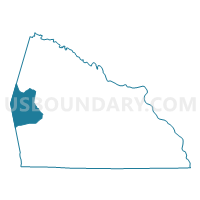
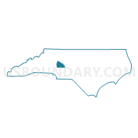
Voting District 24, Rowan County, North Carolina
About
Outline

Summary
| Unique Area Identifier | 641331 |
| Name | Voting District 24 |
| County | Rowan County |
| State | North Carolina |
| Area (square miles) | 28.59 |
| Land Area (square miles) | 28.57 |
| Water Area (square miles) | 0.02 |
| % of Land Area | 99.92 |
| % of Water Area | 0.08 |
| Latitude of the Internal Point | 35.66476340 |
| Longtitude of the Internal Point | -80.73557630 |
Maps

Graphs
Select a template below for downloading or customizing gragh for Voting District 24, Rowan County, North Carolina


Neighbors
Neighoring Voting District (by Name) Neighboring Voting District on the Map
- Voting District 04, Rowan County, NC
- Voting District 07, Rowan County, NC
- Voting District 29, Rowan County, NC
- Voting District BA, Iredell County, NC
- Voting District CC3, Iredell County, NC
- Voting District CH-B, Iredell County, NC
Top 10 Neighboring County Subdivision (by Population) Neighboring County Subdivision on the Map
- Coddle Creek township, Iredell County, NC (32,599)
- Atwell township, Rowan County, NC (12,428)
- Chambersburg township, Iredell County, NC (11,344)
- Barringer township, Iredell County, NC (6,533)
- Cleveland township, Rowan County, NC (2,817)
- Steele township, Rowan County, NC (1,725)
- Mount Ulla township, Rowan County, NC (1,692)
Top 10 Neighboring Unified School District (by Population) Neighboring Unified School District on the Map
- Iredell-Statesville Schools, NC (131,920)
- Rowan-Salisbury Schools, NC (130,380)
- Mooresville City Schools, NC (27,517)
Top 10 Neighboring State Legislative District Lower Chamber (by Population) Neighboring State Legislative District Lower Chamber on the Map
- State House District 95, NC (94,835)
- State House District 79, NC (74,556)
- State House District 77, NC (67,312)
Top 10 Neighboring State Legislative District Upper Chamber (by Population) Neighboring State Legislative District Upper Chamber on the Map
- State Senate District 36, NC (210,610)
- State Senate District 41, NC (207,713)
- State Senate District 34, NC (179,668)
Top 10 Neighboring 111th Congressional District (by Population) Neighboring 111th Congressional District on the Map
- Congressional District 12, NC (736,346)
- Congressional District 6, NC (714,412)
- Congressional District 5, NC (693,414)
- Congressional District 10, NC (689,468)
Top 10 Neighboring Census Tract (by Population) Neighboring Census Tract on the Map
- Census Tract 519.01, Rowan County, NC (4,637)
- Census Tract 518.02, Rowan County, NC (4,574)
- Census Tract 613.03, Iredell County, NC (4,115)
- Census Tract 613.02, Iredell County, NC (3,904)
- Census Tract 607.01, Iredell County, NC (3,044)
- Census Tract 613.01, Iredell County, NC (2,707)